Minor in GeoSpatial Analysis
An interdisciplinary minor in geospatial analysis (GSA) could be used in combination with any undergraduate B.A. or B.S. major. This minor is especially recommended to enhance majors in biological, physical, and social sciences. Requirements for the GSA Minor are:- EB/ES 351 Introduction to Geospatial Analysis (3 hours).
- GE 371 Cartography (3 hours).
- ES 551 Computer Mapping Systems (3 hours).
- Elective courses (9 hours). Electives to be selected upon approval of student's advisor. Independent study and special course projects are encouraged.
Courses in Geospatial Analysis
Software and Data
IDRISI for Windows is the primary software system used for geospatial analysis, image processing, and map display. Also available are ER-Mapper and ArcView software. The GSA Lab has a large collection of conventional maps, air photos, space-shuttle photography, satellite imagery, and GIS databases. New maps and digital databases are acquired continually through the U.S. Geological Survey depository Map Library program.
Back to top of page.
According to established
records, the maximum historical lake elevation was
attained in the early 1800s, when it exceeded 1440
feet (439 m). After the 1860s, lake level
declined until 1940, when it fell to its lowest
historical elevation of 1400 feet (427 m), at
which time the lake was only 1 m deep. The lake
subsequently rose and exceeded 1425 feet (434½ m)
during most of the 1980s.
Following a slight decline in the late 1980s and early 1990s, the
lake is again rising; the water surface surpassed 1442 feet (439½
m) elevation during the summer of 1997. Rising water threatens
to flood the city of Devils Lake and other human facilities
nearby.
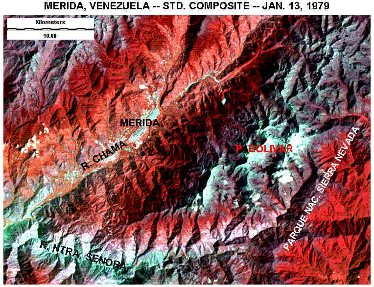
The high mountain peaks supported many glaciers
during the Ice Age, and very small glaciers still
exist on Pico Bolívar, which is snow covered much
of the year. Most rain/snow falls on the southeastern side of
the major mountain ridge located to the southeast
of Mťrida. Annual precipitation exceeds 2½ m in
this zone; whereas the RŪo Chama valley generally
has less than 1 m annual precipitation.
Semideciduous forest predominates at lower
elevations on wet slopes, and evergreen
(siempre-verdes) forest is found at elevations up
to around 4000 m. Alpine shrub (pŠramo) vegetation
is developed above 4000 m. Much of the pŠramo zone
is within the Parque Nacional Sierra Nevada. The
lower, dry valleys have desert vegetation . Main
agricultural crops of the region include potatoes
and carrots, which are grown year round; cattle are
grazed in high meadows.
Back to top of page.
Opportunities in GIS
Geospatial analysis is a rapidly emerging, inter-disciplinary
technology. It combines geography, remote sensing, computers,
cartography, and information networks for dealing with practical
and scientific problems of the world. Geospatial analysis is now
used in many governmental, commercial, educational, scientific,
engineering, and military situations.
Recommendations
Shaping the Future recommendations followed in the geospatial analysis
(GSA) program at ESU include the following.
![]()
Ft. Leavenworth, Kansas
Landsat TM false-color composite made of bands 3, 4 and 5, color coded as blue,
green, and red. In this composition, active vegetation appears green (forest) and
yellow-green (crops, prairie). Purple indicates bare ground and urban areas, and
water is blue/black.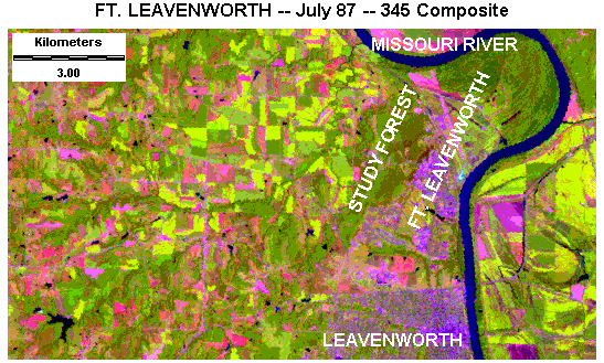
Devils Lake, North Dakota
Standard false-color composite image of Devils Lake, North Dakota, 23 Sept. 1988. Landsat
MSS bands 1, 2 and 4 color coded as blue, green, and red. This autumn scene depicts active
vegetation in red and pink. Sullys Hill (scene center) is covered by deciduous forest.
Note suspended sediment (light blue) in West Bay portion of Devils Lake. This image shows
Devils Lake at a high-water stage that existed during the mid-1980s.
Mérida, Venezuela
Landsat MSS false-color composite image of Mérida vicinity, western Venezuela.
The image is
created from bands 1, 2 and 4, color coded as blue, green and red. Pico Bolívar
stands 5007 m in altitude. Bare rock, soil, snow, ice, urban and clouds appear in white/blue
colors. Red indicates forest; light pink shows agricultural fields. Image date:
Jan. 13, 1979.